


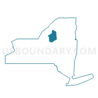
Voting District 010004, Lewis County, New York
About
Outline

Summary
| Unique Area Identifier | 629521 |
| Name | Voting District 010004 |
| County | Lewis County |
| State | New York |
| Area (square miles) | 142.55 |
| Land Area (square miles) | 140.05 |
| Water Area (square miles) | 2.50 |
| % of Land Area | 98.24 |
| % of Water Area | 1.76 |
| Latitude of the Internal Point | 43.99258610 |
| Longtitude of the Internal Point | -75.32613220 |
Maps


Graphs
Select a template below for downloading or customizing gragh for Voting District 010004, Lewis County, New York


Neighbors
Neighoring Voting District (by Name) Neighboring Voting District on the Map
- Voting District 010001, Lewis County, NY
- Voting District 010002, Lewis County, NY
- Voting District 010003, Lewis County, NY
- Voting District 030001, Lewis County, NY
- Voting District 030002, Lewis County, NY
- Voting District 120001 120002, Lewis County, NY
- Voting District 160001, Lewis County, NY
- Voting District 190002, Herkimer County, NY
- Voting District 220004, Jefferson County, NY
- Voting District 220005, Jefferson County, NY
Top 10 Neighboring County Subdivision (by Population) Neighboring County Subdivision on the Map
- Wilna town, Jefferson County, NY (6,427)
- Croghan town, Lewis County, NY (3,093)
- New Bremen town, Lewis County, NY (2,706)
- Watson town, Lewis County, NY (1,881)
- Webb town, Herkimer County, NY (1,807)
- Diana town, Lewis County, NY (1,709)
Top 10 Neighboring Unified School District (by Population) Neighboring Unified School District on the Map
- Carthage Central School District, NY (14,592)
- Beaver River Central School District, NY (5,548)
- Harrisville Central School District, NY (2,350)
- Webb Town Union Free School District, NY (2,228)
Top 10 Neighboring State Legislative District Lower Chamber (by Population) Neighboring State Legislative District Lower Chamber on the Map
Top 10 Neighboring State Legislative District Upper Chamber (by Population) Neighboring State Legislative District Upper Chamber on the Map
- State Senate District 51, NY (296,420)
- State Senate District 48, NY (294,748)
- State Senate District 47, NY (292,134)
Top 10 Neighboring 111th Congressional District (by Population) Neighboring 111th Congressional District on the Map
Top 10 Neighboring Census Tract (by Population) Neighboring Census Tract on the Map
- Census Tract 609, Jefferson County, NY (6,169)
- Census Tract 9502, Lewis County, NY (4,463)
- Census Tract 9501, Lewis County, NY (2,675)
- Census Tract 115.02, Herkimer County, NY (2,258)
Top 10 Neighboring 5-Digit ZIP Code Tabulation Area (by Population) Neighboring 5-Digit ZIP Code Tabulation Area on the Map
- 13619, NY (10,901)
- 13367, NY (8,830)
- 13648, NY (2,424)
- 13620, NY (2,197)
- 13327, NY (2,056)
- 13665, NY (882)